Smart Tech
2024 Legacy Award Winner Lanny Faleide Reflects on a Lifetime of Innovation in Ag Tech

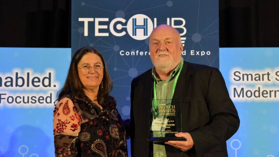
Satshot founder Lanny Faleide accepts the 2024 CropLife Ag Tech Award of Excellence in the Legacy category from Editor Lara Sowinski during Tech Hub LIVE in Des Moines, IA.
Editor’s Note: The annual CropLife Ag Tech Awards of Excellence are presented each year during the Tech Hub LIVE Conference and Expo. Over the next several months, CropLife will profile each of the 2024 winners to see what they are working on currently and how being recognized as a CropLife Ag Tech Awards of Excellence winner has benefitted them personally and professionally. Here we profile Satshot founder Lanny Faleide, winner of the 2024 Legacy Award.
It was nearly 30 years ago that Lanny Faleide launched Satshot, a global imagery service for the precision agriculture industry.
From an early age, Faleide loved imagery, and he loved space. Seeing the TV broadcast of the first moonwalk made a profound impression on him.
Shortly after starting college in the early 1970s, Faleide quit school to return home and help his father farm. At the time, the U.S.-Soviet Union grain deal had tripled the price of wheat.
Like many others in his age group who grew up on family farms, Faleide thought this might be a once-in-a-lifetime chance to “become millionaires,” he recalls.
Although he didn’t achieve millionaire status, Faleide did earn his private pilot’s license.
“In 1977, I was taking pictures of our crops with near-infrared film and my 35 mm camera,” he says. “Because I was looking at the crops from above and was seeing all the variation that were going unaddressed, that stayed in my head.”
From that moment on, imagery was at the forefront for Faleide.
Likewise, the satellite imagery sector was also beginning to take off, thanks to interest generated by the Apollo moon missions and the stunning images of earth taken from space.
NASA’s Landsat 1 satellite launched in 1972, marking a new age of remote sensing of land from space.
The U.S. farm crisis of the 1980s proved to be a “very difficult financial decade” for Faleide and his wife. After many years in the agriculture business, they decided to change careers. He gave up his rented farmland and concentrated farming on his and his family’s land.
Faleide enrolled in GIS classes at North Dakota State University.
In 1986, France launched its first commercial satellite, SPOT 1.
Shortly thereafter, Faleide started “dabbling” in satellites, and the idea to launch his own satellite imagery company soon followed.
A big break came during a routine trip to the grocery store where Faleide ran into a childhood friend who was working with the Crystal Sugar company. Faleide mentioned his budding satellite imagery company and asked his friend if he could connect Faleide with someone at Crystal Sugar so he could pitch his services.
It turns out, his friend was that person.
“He gave me my first $92,000 contract within a year. That was my start-up money,” says Faleide.
Owning the Space
Faleide has pioneered the use of satellite imagery in agriculture — and made it commercially viable.
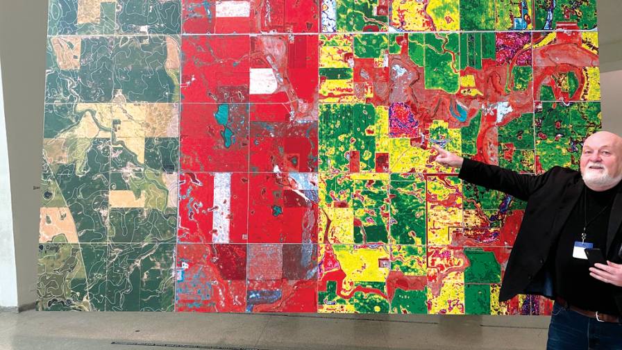
The Guggenheim commissioned Lanny Faleide to contribute his work to “Countryside, The Future.” The exhibit was on display in New York City from February 2020-2021.
Today, there are hundreds of companies and researchers with funding from grants, private equity, and venture capital, doing work similar to Satshot. However, Faleide was the first to combine propriety knowledge and technology with satellite imagery and offer these products and services to the agriculture industry.
“We were ahead of everybody in the beginning. And in many ways, we still are today,” he says.
One advantage was Faleide’s nephew, who was head of programming for flight simulators at Northwest Airlines in Minneapolis in the mid-1990s.
“He built our first software,” says Faleide, which helped established Satshot’s business model of using satellite imagery to support precision agriculture, agronomy, and provide a variety of analytics.
In basic terms, Satshot uses satellite imagery from multiple sources — commercial companies and government, and private and open-source data — which is then uploaded to Satshot’s hub in the cloud. It’s then joined with a mapping system framework, like Google or Apple.
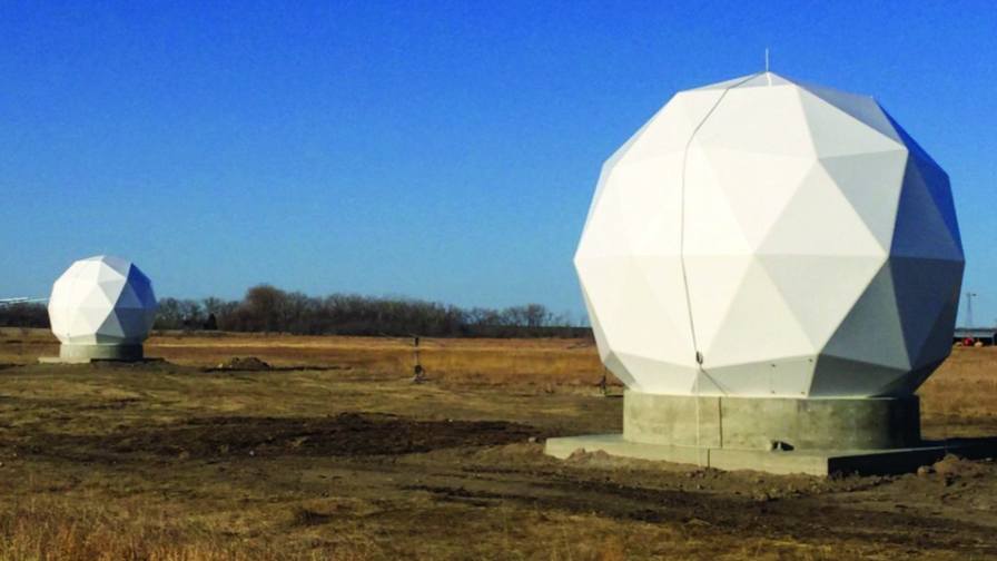
Satellite receiving stations on Lanny Faleide’s land in North Dakota.
Subscribers can use Satshot to view their field and look at satellite imagery every five days, whether weather conditions were cloudy or clear, with the added capability to go back multiple years for historical purposes.
From there, the subscriber chooses the type of analysis he/she wants, such as NDVI (Normalized Difference Vegetation Index).
Simply put, Satshot’s imagery identifies the “good, bad, and ugly” in the field, says Faleide, which helps optimize a plan by accurately evaluating the variability in field conditions and determining what’s required with regards to crop protection products and application. It’s taking data and putting it in a form that’s workable on a farmer’s field.
Not only has the technology changed over the years, but so too has the cost.
In the early days, one satellite image that covered 120 miles wide by 120 miles long was about $4,400.
Today, Faleide can access very high-resolution images at a more affordable price, and he downloads a lot of them.
“We automatically download between 400 and 500 satellite scenes daily and each one is about 300 megabytes in size,” he notes.
A petabyte is one million times larger than a gigabyte, and Satshot has about two-thirds of a petabyte of data stored in its cloud infrastructure.
The company is expanding in other ways.
“Not only do we provide data and analytics for agronomy and precision ag, we’re also renting land to space companies who put up equipment to collect imagery from space. It’s kind of an interesting business model,” says Faleide.
Reflecting on his legacy and his work, Faleide says he always has faith in what he set out to do, namely helping farmers by using satellite imagery and technology.
While his “stubborn Norwegian” tenacity has gotten him through some trying times, the key to success is “don’t quit,” Faleide emphasizes, “and believe in what you’re doing.”
Admittedly, “It can take its toll every now and then,” he says, “but it’s been a very fun ride.”
For more Smart Tech topics, click here.
Subscribe Today For
