The Many Needs For Visual Guidance
 April 1, 2012
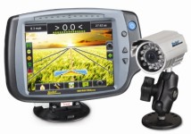
On the surface, it seems like a fairly simple question: What’s new with visual guidance systems? However, according to Mike Olson, North American sales manager for Ag Leader Technology, a completely thorough answer depends upon a number of factors. “In today’s agricultural world, the concept of visual guidance can mean different things to different users, depending on what they are using the systems for and how detailed they are,” says Olson. “The short answer is ‘lots.’”
At one extreme are those users who want visual guidance systems to simply serve as “an extra set of eyes” in the field. “Even today, there are still a lot of people in agriculture that are just getting into the whole visual guidance arena,” he says. “And this group is still learning how to adopt the technology to what they want to accomplish in the field.”


Adds Ryan Molitor, marketing supervisor, Applied Technology Division for Raven Industries, this group of users have to be taught that visual guidance isn’t that complicated to implement into their operations. “There are still many folks out there in the market that haven’t adopted visual guidance systems into their businesses because they have a perception — right or wrong — that there is too much complexity involved to get them to work properly,” says Molitor. “Their thinking seems to be that they don’t have enough acres to justify the cost.”
For this crowd, Raven offers its Cruizer II unit as an option. Built with a color touchscreen display, Cruizer II gives users a downfield three-dimensional (3D) perspective to check coverage and field lines. “Cruizer II is simple to use and offers users a quick payback,” says Molitor. “But the unit is versatile enough that users can eventually add more sophisticated features as they get more comfortable with the technology. This includes options for boom section control and automatic steering.”
Simple Needs
Ag Leader’s Olson says his company takes a similar approach with early adopters. “We tell these users that there is a lot more to precision farming than just the visual guidance part of it,” he says. “So we advise them to find a system that is simple to use at first, but offers some kind of expandability as their need for more sophisticated abilities grow.”
To these users, Ag Leader has a pair of products — the Versa and Integra display. The Versa display has a broad range of features, says Dave King, marketing manager, including guidance/steering, planter control, application control and yield monitoring standard. More sophisticated options such as autoswath and boom height control can be unlocked as needed.
“But if the user wants to upgrade to the Integra, it’s as easy as disconnecting the Versa and plugging in the Integra,” says King. “All connections are the same between the displays and file formats data can be transferred between the displays with a USB drive. There is no need to load the files into an external software package.”
TeeJet Technologies has a similar set-up with its Matrix Pro Guidance system when it comes to users. According to Dave Brackmann, technical support specialist, the Matrix Pro is easy to use on the most basic level, but can be upgraded to run the company’s Field Pilot and BoomPilot options “easily.”
Jeff Farrar, director of marketing for Hemisphere GPS, agrees that this “adaptability approach” is a great way to introduce users to the concept of visual guidance systems without overwhelming them with technology jargon. “There are still smaller users out there that just want some visual guidance and nothing more for the time being,” says Farrar. “We are happy to help these folks find what they need, such as our Outback STS and S3 systems. But we also suggest to them that they purchase a system that allows them to make some upgrades so they have something to build upon in the future.”
The Data Quest
On the other end of the scale of visual guidance users are those that have already gotten pretty familiar with the technology side of things and are now looking to taking some “next steps” in their operations. “Let’s face it — this used to be a very hardware-driven business not too many years ago,” says Randy Wulf, regional sales manager, South-Central U.S. for Trimble. “Now, however, we are moving into more software-driven options, particularly for improved data management. These customers are very used to the technology out in the market, but now they want to be able to use it more effectively to boost their bottom lines.”
To take advantage of this trend, Trimble offers its Connected Farm system. An integrated operations management solution that combines industry-leading hardware and software to increase efficiency and effectiveness for today’s farming business, Connected Farm enables “improved management of farming operations between the field and office through wireless communication from handheld-to-office, vehicle-to-office, and now vehicle-to-vehicle,” says Wulf. “The newly released Vehicle Sync option enables vehicle-to-vehicle communication between operators in the same field, allowing them to share coverage maps, A/B guidance lines and other pertinent field data, saving time.”
Marty Cook, North American sales manager for Topcon, agrees that this need for “better data management” is a key market driver. “The biggest trend you will see in the visual guidance market in 2012 is the desire for better data transfer abilities from the systems,” says Cook. “How users out there put this together and make it work for them will be a big push this year.”
To this end, Topcon offers its X30 console as part of its System 350 as an option. The console is equipped with ISO functionality so it can “plug-and-play” with any ISO compatible implements. Last November, the company added the ability for the X30 to interface with NORAC’s boom leveling system via ISO.
Then, adds Cook, there is the X30’s large 12.1-inch touchscreen display. “This features multi-touch, drop-and-drag capabilities for the user,” he says. “In this sense, it’s a lot like another popular piece of technology out in the market today, the iPad.”
Too Much Data
However, cautions Harlan Little, business manager for Leica Geosystems, just collecting massive amounts of data isn’t what more users should be looking to do with their visual guidance systems. “I’ve never seen answers magically fall out of heaps of data,” says Little. “Lots and lots of data collection can lead to confusion for the user. They first need to ask some good questions before digging into their data management plans. I would suggest trying to find answers to a top two or three questions, not trying to figure out a top 20.”
For these users, Leica has the mojo3D guidance display. “The Leica mojo3D guidance display is a smarter precision guidance system, loaded with industry leading advances designed to help save time and money,” says Little. “It has multiple upgrade options so it can be customized to fit a user’s individual needs.”
Subscribe Today For
