The Future of Remote Sensing in Agriculture

At Planet, we have been working with companies in agriculture for over 10 years, pushing the boundaries of what is possible with remotely sensed data within the industry. We work with established companies like Bayer, Syngenta, and BASF as well as newer AgTech companies like Taranis, Arva, and FarmQA. We also have a depth of internal agriculture expertise.
Agricultural researchers first saw the promise of remote sensing after the launch of Landsat 50 years ago. While the industry could see the promise of what this technology had to offer, there were many steps that needed to occur to recognize this promise. The first hurdle was the availability of the data. With hundreds of satellites in space collecting images of the Earth’s land mass daily, Planet solved for that constraint and moved onto the next set of challenges. In 2022, Planet’s next generation 8 band PlanetScope launch provided significant imagery enhancements, enabling our customers to gain richer, cleaner, and more consistent data to empower deeper analysis of Earth’s changing conditions.
The new frontiers are now around pipeline simplification, analytic building blocks, and utilizing a variety of remotely sensed layers together to answer higher level questions. This enables the agriculture industry to solve new and exciting use cases as well as cut costs to maintain existing ones.
At Planet, we are making huge strides with pipeline simplification through our partnership with Sinergise and utilization of their flagship Sentinel Hub tools. Simplifying the data pipeline allows partners and customers to lower the cost of using remotely sensed data and focus on building differentiating value on top of imagery rather than focusing on basic infrastructure.
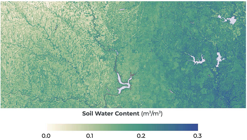
In addition to pipeline simplification, we are working our way up the stack at Planet, offering more sophisticated building blocks to speed time to value for our customers. It starts with data feeds that can deliver continuous, scientifically rigorous insights that measure and quantify the changing conditions of the surface of the Earth called Planetary Variables. These Planetary Variables, like Soil Water Content, offer baseline analytics that our partners and customers combine with other data sources to create robust solutions. These solutions span use cases such as irrigation management with partners like Nave Analytics, yield estimation for commodity trading, and drought insurance with customers like AXA Climate.
In the industry, we are best known for our near daily imagery captured by our SuperDove constellation which enables successful business models for agriculture. In the coming year we expect our SuperDove PlanetScope imagery to also serve as tip and cue for our SkySat and our new constellations including Tanager hyperspectral satellites and 30 cm Pelican satellites.
![]()
Near daily PlanetScope imagery can be used to tip and cue field level activities with emerging smart spraying technologies, and more efficiently field test new sustainable products such as biologicals at scale across different landscapes.
At Planet, we know that driving sustainable change requires collaboration and we are working closely with partners to help drive the digital agricultural revolution. We look to a future where next-gen AI combined with satellite data can help scale and advance agricultural analytics, making it more accessible for all. Down the line, we can envision a queryable Earth, where data can answer the most pressing questions about how we will sustainably feed our planet.