Real Intelligence Starts with Smarter Soil Insights

Innovative ag technology unlocks secrets below the surface
As trusted advisors, growers look to you for new and detailed insights above and beyond what they have access to alone. New tools from EarthOptics bring a wealth of data to your fingertips, meaning you can dig into what matters most to your customers – and have the greatest impact on their bottom line.
Using military and space technology, EarthOptics delivers science-based tillage and fertility decisions, compaction quantification and accurate carbon measurement, resulting in more valuable data than ever before.
How does it work?
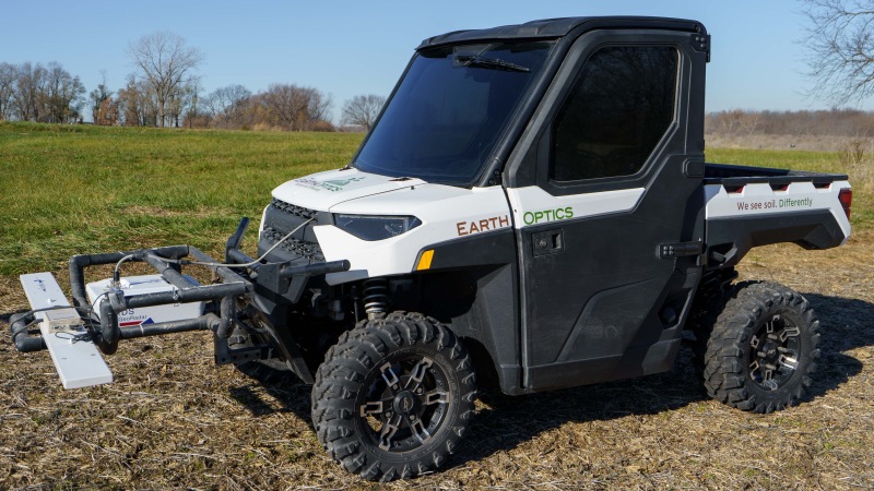
EarthOptics GroundOwl™ – a sensor suite mounted to an ATV, side-by-side or tractor – is driven over the field. The sensors, combined with new artificial intelligence (AI), build a digital twin of the soil in the cloud. EarthOptics measures how soil varies, producing dozens of data points per second and generating more data points in a field than any other method of soil analysis.
EarthOptics verifies accuracy in the field by taking dense soil samples. After the GroundOwl™ sweeps the field with its sensors, the technology uses AI to produce a hyper-accurate, high-resolution map on all soil attributes. AI gets smarter over time so fewer physical samples are required to achieve a high level of accuracy.
Tillage Mapping
Soil compaction reduces drainage and aeration while increasing runoff and erosion, and even moderate compaction can inhibit root growth. Deep tillage loosens the soil, but it’s a costly and time-consuming process. More and more growers are interested in reducing tillage for cost and labor savings as well as the soil health benefits but find their field conditions still require tillage to break up compaction.
To solve this problem, EarthOptics’ sensor technology measures soil compaction and provides actionable information to adjust management practices, saving time and money. This mapping system identifies and measures soil compaction to a depth of three feet and quantifies the extent of the compaction, in addition to changes in soil texture, carbon content, conductivity and nutrient properties. The technology creates an opportunity for trusted advisors to deliver immediate cost savings to their growers.
TillMapper™ uses the collected data to create a customized 3D tillage prescription that can be adjusted to the grower’s preferences, including compaction threshold, max tillage depth, and anticipated crop. The output can be exported as either a multi-depth prescription or a binary till/no-till prescription. As a result, growers have the information and ability to till only where needed and to quantified levels.
Soil Fertility
Soil fertility information is essential for growers and their advisors to make informed decisions about how to manage soil. Tracking N, P, and K is the backbone of most soil analysis. EarthOptics takes that old system and leaps forward to give growers the elemental and nutrient analysis on crops in a manner that is actionable and easy to digest. What is measured can be managed. This deeper understanding of soil fertility means inputs can be optimized for higher yields and profitability, based on individual goals and objectives.
Carbon Measurement
With the carbon market becoming a booming opportunity, accurate measurement of soil carbon is more important than ever. Combining traditional soil samples with the results from GroundOwl™ sensor data, EarthOptics delivers high-resolution maps with accurate total field carbon measurements. This method detects year-over-year changes that demonstrate carbon sequestration in the soil during a crop season. Soil is measured everywhere on the field – delivering efficiency and higher accuracy to agricultural carbon markets.
The results of this technology are real measurements, actionable results and greater efficiency. Visit EarthOptics.com to get started.