Gamma Radiation Mapping: A System for Topsoil Mapping and Variable Rate Nutrient Application
 December 27, 2019
 There are many steps that a Certified Crop Advisor (CCA) and the farmer need to take to ensure that their precision agriculture equipment is being used efficiently. When industry, or CCAs, talk of “precision agriculture” they are often selling a service or piece of equipment that can vary seed or nutrients across a field.
The sales pitch could also be for a “platform” that can manage the vast amount of agronomic and machine data that new planters, sprayers, and combines can collect geospatially as they move across a field. It is essential, however, to gather high resolution soil information as a base for all variable rate applications (VRA) of seed, nutrients, and other soil amendments.
Precision agriculture needs high-resolution maps of physical and chemical soil properties together with yield and crop biomass maps to enable operational decision support in crop management and to conjure VRA maps1.
The measurement of gamma radiation emitted from soils has been studied for many years. In the early 1930s, gamma radiation sensors were being used in mineral exploration for uranium2. Many mature CCAs and older farmers are probably familiar with the “Geiger counters” that were used to measure radiation in the years following World War II. These early sensors were referred to as Geiger-Muller counter-based sensors. The development of scintillator crystals provided a more accurate method of measuring radiation and an algorithm-based process was developed to break the radiation down into a series of constituents, the naturally occurring elements of potassium, thorium, and uranium.
Many developments in the field of gamma radiation measurement have occurred, including calibration of the sensors, and it was discovered that as a general rule different soil and sediment types can be characterized as unique fingerprints 3.
Applicability of gamma-ray spectrometry to soil investigation works due to initial compositions of radionuclides in bedrock minerals (K, U, Th) or to human impacts (Cs). With natural weathering and soil erosion processes, this causes a different distribution of radionuclides over particle sizes and subsequent different environmental behavior leads to redistribution processes at various spatial scales. Gamma-ray measurements, thus, can help to differentiate between bedrock and soil, and detect weathering intensity, textural properties, and nutrient status of the latter4.
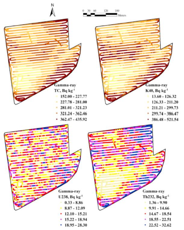
Spatial distribution of Gamma-ray measurements within the study field. Four broad spectral windows corresponded to potassium (K40), uranium (U238) and thorium (Th232) and total count (TC). Note that the scale of the measurement varied between plots. (Wenjun Ji, et al, 2017) Click to enlarge.
A case study to characterize soils using multiple proximal soil sensors and data fusion techniques was conducted at the McDonald Campus of McGill University in Quebec5. Improved predictions were observed for most soil properties based on sensor data fusion than those based on individual sensors. After choosing the optimal sensor combination for each soil property, the predictive capability was compared using different data mining algorithms. In the study, proximal soil sensor data fusion was defined as a multifaceted process which integrates geo-spatially correlated data, or information, from multiple proximal soil sensors to accurately characterize the spatial complexity of soils.
This has the capability of providing improved understanding of soil physical and chemical properties that will allow variable rate technologies (VRT) to improve the efficiency of inputs, such as seed, commercial fertilizer, organic amendments, and pesticides such as fungicides, thereby creating more sustainable crop management systems.
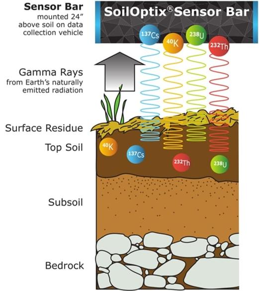
In Ontario, a new company SoilOptix Inc., has developed proprietary algorithms and a reference soil sampling protocol to predict, with a high degree of accuracy, the in-field variability of soil physical and chemical properties. The SoilOptix topsoil measurement system uses a Csl-based scintillation detector connected to a tailor-made spectrum processing unit. The CsI crystal was chosen over the more common NaI crystal because of the robustness and increased efficiency.
The system utilizes a real-time kinetic (RTK) global navigation satellite system (GNSS) receiver with a base station that is placed at the highest elevation and in the approximate center of the field to be mapped. Data acquisition takes place via proprietary software; a Windows application that runs on a standard PC or laptop. The data is stored in records containing energy-stabilized gamma-ray spectra, together with count rate and activities of 40K, 238U, 232Th and 137Cs. Data collected is processed with the reference soil lab results to develop the individual layer maps for soil physical and chemical properties.
Click to enlarge.
An experienced CCA with knoweledge of the field’s crop and nutrient history can now analyze the individual layers and develop management options for the farmer that are unique to each field. Researchers have coined the information gathered with gamma radiation systems as “fingerprinting” the field. Often the data uncovers small areas coined “Easter eggs” that have unique characteristics, such as low pH or high magnesium. These unique areas can then be amended using equipment with GPS and VRT capability. Often farmers have found that these systems uncover information that was not revealed using traditional 2.5 acre resolution grid sampling.
Gamma-ray spectrometry combined with RTK elevation is one example of a multiple proximal soil sensor system that has emerged as a helpful tool for rapid soil mapping. An experienced Certified Crop Advisor armed with multiple layers of high-resolution soil data, that includes physical and chemical properties, can now provide action plans for farmers that will allow efficient use of equipment with VRA technology. In accomplishing this task, the CCA will also be creating sustainable crop management plans that utilize finite resources or environmentally sensitive materials such as phosphorus and nitrogen-containing commercial fertilizers, manure or other organic amendments.
Footnotes:
-
Gamma-ray sensor for topsoil mapping; the Mole. (F.M. van Egmond, et al., 2008)
-
Heavy minerals: from ’Edelstein’ to Einstein. J. of Geochemical Exploration. (de Meijer, R.J., 1998)
-
Radiometric sand-mud characterisation in the Rhine-Meuse estuary Part A: Fingerprinting. Geomorphology. (Van Wijngaarden et al., 2002)
-
Use of airborne gamma radiometric data for soil mapping. Australian Journal of Soil Research (Cook, S.E., et al, 1996)
-
Simultaneous measurement of multiple soil properties through proximal sensor data fusion: A case study (Wenjun Ji, et al., 2017)
Subscribe Today For
