Using Autonomous Drones for Smarter Agronomic Decisions
There is an emphasis on the speed and quality of decisions in modern farming today. Agronomists, advisors, and growers need to assess the health of the crop, the status of the soil, and the moisture, pests, irrigation, and inputs in farming units that can extend to huge distances and across many dispersed locations. The challenge is not collecting more data. Rather, the challenge is collecting data at the right time to create accurate and timely field decisions. With drones taking to the skies as part of the process, agricultural decisions will be aided by high-resolution 4k cameras, thermal cameras, multispectral sensors, and increased autonomy in flights and tools in the cloud to analyze data.
This perspective, combined with agronomic knowledge and confirmed on the ground, can aid professionals in seeing variations in their scouting efforts in problem areas. It is not about avoiding the need for agronomists or traditional scouting. It is about offering agricultural employees another layer to make field decisions at greater speed.
From Field Observation to Actionable Agronomic Intelligence
Ground field scouting is still an integral part of crop management. When you walk through your fields, you can look at your plants, evaluate symptoms that you may not be able to otherwise evaluate by remote sensing, and assess pest pressure and the overall field conditions. This ground scouting does not solve one problem: scale. An agronomist responsible for large fields- hundreds or thousands of acres simply cannot keep constant watch over all parts of all fields. An issue may appear on just a small portion of a field or in an area that a farmer can observe and go undiscovered until much later.
Drone use can remedy some of this observation problem.
The aerial perspective allows the agronomist to easily identify varying conditions within the crop and distinguish them from the surrounding crop. The adviser can then use the aerial photograph not as a diagnosis, but as an indication of where on the ground their presence is necessary to make better observations. This makes for a more directed response: survey through the field, identify where there is some variation, ground-truth the anomaly, identify the cause, determine if there are conditions present that require action.
The latter aspect is important: technology tells the adviser where to look, while agronomy will dictate what the observation tells them and what needs to be done.
Why Autonomy Changes the Value of Agricultural Drones
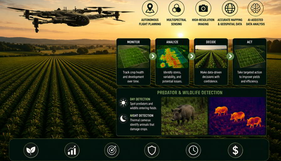
Agricultural drones are not novel, but the use of autonomous drones has opened up some possibilities. A manually flown drone can give you great images that can be useful from one flight. However, an autonomous system can follow predetermined paths and perform data collection missions over time. This helps to compare field conditions between stages of crop growth. This is not just a snapshot; agronomists can start to identify trends. Drones can also help detect wildlife or predatory animals entering agricultural fields and potentially damaging crops. During nighttime operations, thermal cameras can help identify heat signatures of animals that may otherwise be difficult to spot, enabling growers to monitor vulnerable areas and take appropriate preventive measures.
- Is an area of crop stress expanding?
- Has plant vigor changed since the previous survey?
- Did a crop respond as expected after an intervention?
- Is the same section of the field repeatedly showing moisture-related stress?
- Should a particular area receive immediate ground scouting?
- Are wild animals or predators entering the field during the day or night and causing crop damage that requires closer monitoring?
For growers and advisers exploring Autonomous Drones for Agriculture, this capability of repeatable aerial observation and sensor-generated field data is especially significant. Agricultural drone systems can be used to help with field mapping, monitoring crop health, tracking growth, and precision agriculture management.
Features That Matter in an Agricultural Drone
There is more to an agricultural drone than the ability to fly. Agronomic applications are affected by the capabilities that influence the usefulness of the information collected.
- Autonomous and Repeatable Flight Planning: Repeatable flights are valuable for crop monitoring. Autonomous drones follow predefined routes, allowing agronomists to survey the same areas regularly, compare crop development, track changing field conditions, and identify farm issues.
- Multispectral Sensing: Multispectral sensors reveal crop variations that may be difficult to detect physically. By capturing data across different wavelengths, drones help agronomists identify vegetation changes and prioritize areas for closer field investigation.
- High-Resolution Imaging: High-resolution aerial imagery supports field inspection, mapping, & crop comparisons. Repeated flights create a visual record of crop development, helping agronomists make informed decisions.
- Accurate Mapping and Geospatial Data: Geospatial mapping links aerial observations to exact farm locations, helping advisers verify anomalies, compare farm data, and support irrigation, drainage, and field variability analysis.
- AI-Assisted Data Analysis: AI/machine learning helps process large volumes of drone imagery, identify patterns, and flag anomalies. By filtering complex datasets, AI enables agronomists to focus on agricultural land conditions that need closer investigation and action.
Benefits of Agricultural Drones Technology
While features are important, agricultural companies need to see operational advantages too. Therefore, the most legitimate argument for using drones is their ability to enhance existing agricultural processes.
Faster Field Assessment
One of the main benefits of using an aerial platform is being able to survey a large area at one time. This means there’s less time needed traveling between fields, as instead of a person walking through them, aerial views give the advisor an overview of the tasks ahead. This is particularly valuable for larger agricultural businesses, which would be unable to survey all areas of their land frequently.
More Targeted Crop Scouting
The process of scouting can be made more targeted using these drones. When the aerial survey images clearly highlight an area that may need investigating further, the agronomist will be able to investigate this specific area when conducting field scouting; once the area has been checked, the advisor should have a diagnosis of whether the issue is pest, disease, nutrient deficiencies, lack of moisture, soil differences, etc.
Earlier Identification of Potential Problems
Timing can have a significant effect on crop-management options. Regular aerial monitoring/inspection can help reveal developing patterns or changes in crop conditions between conventional scouting visits. Real-time awareness allows agronomists to investigate before a localized issue becomes more extensive.
Importantly, an aerial anomaly should be treated as an indication for further evaluation rather than automatic proof that improvement is required
Better-Informed Input Decisions
Precision agriculture is fundamentally about matching management decisions to actual field conditions. If crop variability is concentrated in specific areas, blanket treatment may not always be the most appropriate response. AI-Powered Drone information can help identify where additional investigation is warranted before fertilizer, crop-protection products, irrigation, or other interventions are recommended.
This can support a more evidence-based inspection between growers and advisers.
Improved Resource Efficiency
Better field intelligence can also support more efficient use of resources. Knowing where a problem exists and where it does not can help operators prioritize labor, scouting time, equipment, water, and agricultural inputs. This has both economic and sustainability implications. Precision does not necessarily mean using fewer inputs in every situation; it means using resources more deliberately according to field requirements.
Consistent Crop Monitoring
A single aerial survey or inspection has limited value compared with a sequence of observations collected throughout a season. Repeatable autonomous flights can provide a chronological view of crop development. Agronomists can compare conditions before and after interventions, follow developing areas of concern, and maintain a more consistent record of field performance.
Improved Safety and Accessibility
Agricultural operations can include difficult terrain, large plantations, wet fields, remote areas, and locations that are inefficient or potentially hazardous to inspect physically. Remote aerial observation can provide initial visibility into these areas before personnel enter them.
Drone Technology therefore has value not only in crop analytics but also in helping organizations decide when and where physical inspection is necessary. For growers and agribusinesses evaluating drone technology, this Agriculture drone guide provides useful insights into features and considerations when selecting a drone for modern farming operations.
From Data Collection to Better Input Efficiency
For ag retailers and crop advisers, one of the most significant opportunities lies in connecting drone information with input recommendations. Consider a field showing uneven crop performance. A conventional response might begin with broad physical scouting. With aerial intelligence available, the adviser can first identify the areas displaying the strongest variability. Ground inspection can then determine whether the cause involves moisture, fertility, pests, disease, or another factor.
Only after that diagnosis should an input decision be made. This sequence matters because greater visibility does not automatically justify greater treatment. In some situations, drone-assisted scouting may support a targeted application. In others, it may indicate that an input is unnecessary or that the actual problem requires a different management strategy.
The business value for crop advisers is therefore not simply in producing aerial maps. It is in connecting those observations with sound agronomic recommendations.
Integrating Drone Data with the Precision Agriculture Ecosystem
The drone information is more impactful when it is not viewed by itself. Agronomists have the option to compare aerial observations to soil information, weather data, irrigation records, historical yields and previous applications, and ground-scouting results. Each data set provides context. There is much information generated in agriculture already. The next generation of digital agriculture will rely more on the ability to link the right information in such a way that professionals can make effective decisions.
An area with unusual characteristics in the vegetation may gain in significance when interpreted in the context of moisture or history of performance. AI-powered analytics could be of growing significance here as well.
Drones are one of those information layers – an extremely adaptable aerial layer, ready to be updated during the growing season.
Keeping the Agronomist at the Center
Autonomy and AI sometimes create the impression that agricultural decision-making will eventually become entirely automated. That overlooks the complexity of agronomy. Similar visual symptoms can have very different causes. Local weather, crop variety, soil conditions, growth stage, previous applications, pest history, and many other variables can influence what an agronomist observes.
For this reason, the strongest agricultural drone workflows keep humans in the decision loop.
The drone gathers information.
Software organizes and analyzes it.
The agronomist interprets it in context.
Ground scouting confirms what is happening.
The grower and adviser then determine the appropriate response.
Technology becomes most valuable when each part of that process strengthens the next.
Measuring the Real Value of an Agricultural Drone Program
Agribusinesses evaluating drone technology should avoid judging success by the number of flights completed or images collected.
Better questions are:
- Did the system reduce the time required to assess fields?
- Did it help prioritize scouting?
- Were potential problems identified sooner?
- Did advisers receive useful information for input recommendations?
- Could crop response be evaluated more consistently?
- Did the technology improve documentation and communication between growers and advisers?
These questions connect drone technology to operational outcomes.
Before deploying a system, organizations should therefore define the agronomic problem they want to solve. Starting with a clear use case makes it easier to determine what sensors, flight capabilities, analytics, and workflows are actually necessary.
The Road Ahead for Autonomous Agronomy
The next level of innovation in ag drones will probably be how the autonomous system, AI, onboard sensors and the field-management platform communicate to improve workflows. Rather than just another pair of eyeballs, drones are more promising as automated data gatherers plugged into the precision-ag ecosystem. Imagine the cycle: drones flying scheduled missions across the field, gathering data that gets analyzed automatically with a little human-directed help of AI to identify and flag out-of-normalities; sending an alert to the crop scout; making a ground pass through that section; following up with recommendations based on all your data points. The result: smarter, more strategic management to achieve goals more efficiently-not just more high-tech toys on the farm.
The companies that truly benefit from drone autonomy probably won’t be just anyone; they are the ones who match automation capabilities with strong agronomist expertise toward measurable results on the ground.
Conclusion: Turning Aerial Intelligence Into Practical Decisions
Autonomous drones have the ability to make agronomic decisions faster and with more data. Beyond taking pictures, integrating drones into a structured scouting and decision workflow enables a wide range of capabilities, including field variability observation, prioritizing inspections, tracking crop growth, and informed resource and input decisions. The technology is also continuing to evolve beyond agriculture. ZenaDrone is developing AI-enabled autonomous UAV technology for agriculture as well as applications including inspection, monitoring, mapping, data collection, security, environmental monitoring, and other industrial operations. Its technology includes capabilities such as programmable autonomous flight, 4K imaging, thermal camera, multispectral sensing, terrain mapping, and AI-assisted aerial data collection.
In agriculture, these capabilities can encourage a shift from a system of periodic observations to a system of data-driven observations. Across industries, similar approaches using autonomous aerial operations in combination with sensors and smart software to frequently monitor difficult, large, and/or highly monitored areas are being used.
Subscribe Today For
