Scouting in High Resolution: How Integrated Ag Services Is Taking the Next Step in Crop Monitoring
 June 15, 2021
 Editor’s note: This article originally published in June 2020.
Ohio agronomist Dave Scheiderer, Owner of Integrated Ag Services, is well known for pushing the envelope on incorporating a solid regimen of intense soil testing, in-season data collection, and predictive algorithms to improve the accuracy and efficiency of crop monitoring throughout the season.
His “high-definition” approach to soil sampling requires samples be taken at a rate of ½- to 1-acre grids, which provide the best balance of agronomic accuracy and cost efficiency, and provides a rich background of data upon which to build recommendations.


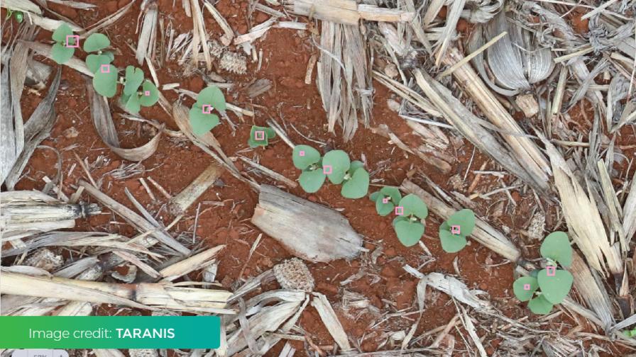
Taranis’ tight resolution identifies plants and allows for highly accurate stand counts. Photo credit: Taranis
As for in-season scouting, Scheiderer has been looking for actionable data that reduces guesswork for farmers and agronomists, and maximizes the expertise of his field staff. 2020 will mark his second season working with imagery solution provider Taranis in an effort to pinpoint stand count and super fine tune recommendations.
“We went through the process of looking at NDVI, and there are things you can glean from it and there’s a place for it,” says Scheiderer. “But we wanted to take that next step — to be able to get a truly accurate stand count, or identify a weed. Taranis technology has been able to provide this for us.”
The tight resolution — down to sub-millimeter — combined with existing soil and field data allow Scheiderer and his team to make next-level recommendations for input application or, when nature strikes, replant. To do it most effectively, though, takes a multiflight season-long approach.
“That was really the big learning from last year’s experience, that you need to create a consistent and predictable system to be effective,” says Scheiderer. “We want to be in the field six times during the season, about every 15 days.” Scheiderer’s crew fly the Taranis drone unit themselves rather than use the service. “You do end up becoming a camera expert,” he adds, “and there are a lot of little things that we as agronomists pick up in the process that someone else would not recognize, so we felt it was best to do it ourselves.”
Early season, the imagery flights capture the all-important emergence and stand count data at the right time and resolution to ensure accuracy. Subsequent flights will detect a range of issues, from fertility problems to mid-season disease and insect issues.
Of course, stand count data also plays into making accurate assessments of damage from severe weather. Old school observations from a distance can be replaced with high resolution visual evidence that can be turned into precise replant prescriptions for portions of fields, telling the farmer where to replant and precisely how much seed they should purchase.
“Scouting is a reconnaissance mission — we hope we never see anything when we are out there, but we know the likelihood of something go wrong is high. That’s why we scout — we’re never sure when problems are going to arise.”
Subscribe Today For
